
If you just downloaded GeoLite, you may wonder what the paid GeoIP databases would add. For some use cases, the extra accuracy decides whether the call is right—and a wrong call costs money or blocks a good customer. For other use cases, the difference will not matter.
We build the two datasets differently. Once you know how and why, you can apply a cost-benefit analysis to inform your decision.
IP geolocation is integral to how the internet works. It runs content localization and geoblocking, and it feeds automated decisions about how traffic and requests get routed. It’s so much a part of the modern internet that some leading providers give a version of it away. We’ve offered GeoLite for almost 25 years under a modified Creative Commons license. We’re still the only major IP data provider with a free dataset that includes city and postal granularity in a downloadable format. As of September 2026, GeoLite powers experiments and applications run by over 200,000 developers and organizations.
How is GeoLite built differently from GeoIP?
GeoLite is less accurate than GeoIP in two ways:
- GeoLite uses fewer of our proprietary data signals, so fewer strong signals go into each geolocation decision.
- GeoLite groups IP addresses into larger ranges, which lowers the granularity of a location or blurs a more precise one.
Fewer proprietary signals
We use many signals, public and private, to work out where a network is being used.
| Geolocation signal | Description | Value | In GeoLite |
|---|---|---|---|
| Public data | Network announcements, RIRs, BGP | Weak signal, low granularity and accuracy, strongest at country level | Included |
| Traceroutes | Rough estimate of where a network might be, based on ping transit time | Medium signal, low granularity, strongest at country and some value for subdivision depending on its size, and not all IPs can be usefully traced | Included |
| Published locations | Network operators may publish server locations in publicly or privately accessible feeds | Medium signal, mixed granularity from country through postal, often does not align with user location | Included |
| Corrections | Network operators, their partners, and individual IP users may submit correction requests | Low to high value signal, mixed granularity from country through postal, very little coverage | Included |
| Proprietary data | We hold proprietary data about where IP addresses are being used | Very high value, good granularity often down to postal level, good coverage | Partially included |
The highest value signals for deciding where a network is in use are our proprietary signals about end-user location. GeoLite uses a lower volume of these, which makes each geolocation decision less accurate, and the effect grows as the location gets finer.
Merged IP address ranges
We also merge geographically close IP address ranges in GeoLite.
Let’s look at a concrete example comparing GeoIP and GeoLite from September 2026. In this example, we’ll look at 2,048 IP addresses that are part of AT&T’s residential ISP services in the Los Angeles area.
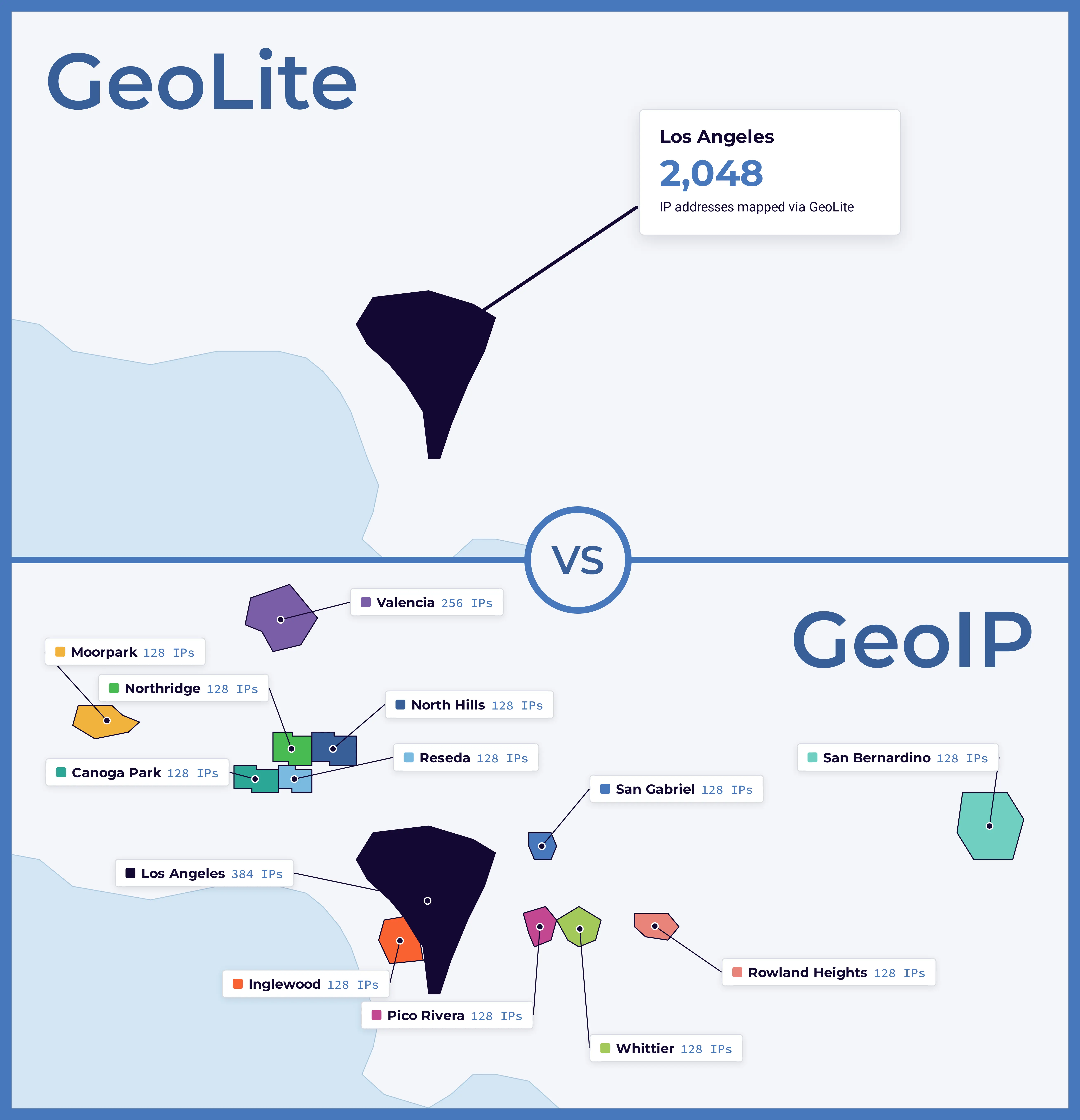
In GeoIP City, these IP addresses are broken down into pools of either 128 or 256 IP addresses. These small IP address ranges are geolocated to 13 different cities/communities, from North Hollywood to San Bernardino. Some of these cities are 160 kilometers (or a 2 hour drive) away from one another. In GeoLite City, all 2,048 IP addresses are located to Los Angeles, the nearest major metropolitan area.
The question is: does this matter for your use case? There may be use cases where you can draw a 100 km radius and just call the whole area Los Angeles, but for many use cases the difference between someone being near Disneyland and someone being near prime camping locations is critical.
Where that leaves accuracy
GeoLite is less accurate in ways that lower the business risk of the data behind it and keep it small enough to work with in a proof of concept.
At country level the accuracy difference is minimal, because the signals both datasets share are usually good enough to tell you which country an IP is likely used in. Higher risk work can still need something finer. Whether a region counts as being in Russia or Ukraine can be lost if your dataset only has the ISO country, and that matters for sanctions compliance and international law. We covered this in our article on IP intelligence in your compliance data stack. For low risk country decisions where contested regions don’t change the outcome, GeoLite Country may be all you need.
GeoIP becomes a clear value-add once you need the subdivision, city, or postal code. It also contains deeper signals, like the confidence of a location, anonymization likelihood, or how users are likely distributed across regions within a range.
What GeoLite doesn’t include
Beyond geolocation accuracy, GeoLite does not include product support nor supporting IP intelligence data to provide context on how to best interpret IP addresses, much of which is relevant even for purely geolocation-focused questions. For example, the proxy or anonymizer status, indicators of shared infrastructure, and the confidence and context of use surrounding a network, all of which can radically change how IP locations should be interpreted based on your use case.
What does a wrong location cost you?
It comes down to a cost-benefit analysis. What is at stake in the decision the location feeds? If you’re helping a prospective customer pick the right store, a wrong answer adds friction and frustration and can end in an abandoned cart. If you’re blocking transactions from sanctioned countries, using the industry-standard paid dataset can go a long way towards showing best effort in compliance and get fines reduced or dropped.
Here’s what we’ve learned working with partners across industries.
Regulatory and sanctions compliance. When a transaction comes under scrutiny, you need to show you took reasonable steps to use the proper technology to comply with requirements. This is true whether you’re avoiding business with sanctioned countries or selling into jurisdictions where you aren’t permitted. Using a free dataset in that decision can invite scrutiny on its own, whatever else you did.
Digital security, fraud, and risk. Protecting your network is high risk work, and identifying the source of an attack benefits from the most accurate information available. Country level is sometimes enough but proxy detection is the real differentiator, which we wrote about in our article on the threat of residential proxies.
Digital rights management. Streamers have to obey region-specific content contracts to keep their partners happy. It falls short when contracts run down to the subdivision or postal level, or when you need to leverage other signals to enforce compliance on mobile networks in border regions. This is increasingly the case in sports and broadcast media.
Ad serving. Most ad serving benefits from the most granular location data available, and country level is rarely enough.
Store selection for inventory and promotions. Getting this wrong costs you user friction and the business that follows it. If all you need is picking a language at the country level, GeoLite Country could work just fine.
You can put numbers on this. Here’s the accuracy difference between GeoLite and GeoIP as of September 2026, for broadband residential IP addresses in the United States.
| Granularity | GeoIP accuracy over GeoLite |
|---|---|
| State | 2% more accurate |
| City and postal | 6% more accurate |
Note that the true accuracy difference for your specific use case depends on the country, the network type, and the granularity you need. You can check the current difference for the locations you care about with our accuracy comparison tool.
You can combine accuracy estimates with volume of decisions to make quantifiable estimates of the business risk this represents, whether that’s due to something that seems small like friction, abandonment, and loss of business, or something big like fines. Even 2% can add up fast on higher volume use cases.
When is GeoLite the right product to use?
Plenty of projects should stay on GeoLite, and we’d rather you use it well than buy data you don’t need. The free data does the job for internal analytics aimed more at exploratory analysis than core KPIs, for prototypes and proofs of concept, or for country-level geoblocking that doesn’t require special attention to conflict regions.
Ask one question to guide your decision: Would a less accurate location cost you money, a regulator’s attention, or a partner’s trust?
Getting help with the decision
If you want help weighing free against paid for your use case, talk to our IP data experts. We are happy to discuss the trade-offs relevant for your specific use case and application.